New VCU Rice Rivers Center Buoy Adds Data to CBIBS
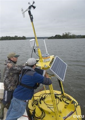 Now you can learn even more about your local waterways with the newest addition to the Chesapeake Bay Interpretive Buoy System (CBIBS) family. This new buoy, owned and maintained by the Virginia Commonwealth University, is located about one kilometer off shore from the Rice River Center in the James River, near Charles City, VA. In addition to the wealth of weather, oceanographic, and water quality data recorded by the CBIBS buoys, the VCU buoy also includes fish sensors to help track fish movement – aiding Atlantic sturgeon and striped bass restoration efforts. Executive Director, Joel Dunn, attended the formal launch event at the Rice River Center on Tuesday, November 19, 2013.
Labelled as the “RC” buoy, data from the VCU buoy is available on the CBIBS website and on the free mobile apps for Android and iPhone. This data will provide essential information to a range of user-groups, including scientists and decision-makers, boaters, educators, and students who want to learn more about the James River, the Chesapeake Bay, and the living resources that depend on them.
The Chesapeake Conservancy was deeply involved in the creation of CBIBS and continues to support the program by advocating for federal funding for the system.