Chesapeake Conservancy Launches Interactive Planning Tool for the Nanticoke River Initiative
Chesapeake Conservancy Launches Interactive Planning Tool for the Nanticoke River Initiative
Annapolis, MD – The Chesapeake Conservancy recently released a new interactive conservation planning tool to enhance conservation efforts along the Nanticoke River. The aim is for this tool to add to ongoing efforts along the Nanticoke corridor to identify new opportunities for conservation and collaboration.
For the past several years, the Conservancy has been engaged in an effort to protect an 8,500-acre wildlife corridor composed of forests, wetlands, and farmland in the Nanticoke River watershed. This Nanticoke River Initiative leverages funding and resources from private, non-profit, state, and federal entities to accomplish more in partnership than could be done by any one organization.
With the recent designation of the Nanticoke River as a priority for the United States Department of Agriculture’s Regional Conservation Partnership Program (RCPP) and the Department of Defense’s Readiness and Environmental Protection and Integration (REPI) program, the partnership has the opportunity to broaden the impact of its current efforts and increase the level of conservation throughout the Nanticoke River watershed. To assist in this expansion, the Conservancy developed the web-based Nanticoke River Conservation Opportunities Analyst that, when combined with each partner’s prioritization scheme, can identify joint priorities for expanding the scope and breadth of the group’s effort.
 With support from the Lincoln Institute of Land Policy, the Chesapeake Conservancy’s Conservation Innovation Center worked with local, state, and federal organizations to combine a series of data layers depicting landscapes that are considered high-value for each of five categories:
- Historical and Cultural Resources
- Ecological Resources
- REPI Areas
- Proximity to Existing Protected Lands
- Proximity to Existing Public Access Sites
Data can also be added to the tool as new layers are developed, allowing the tool, and the partnership, to adapt as new information becomes available.
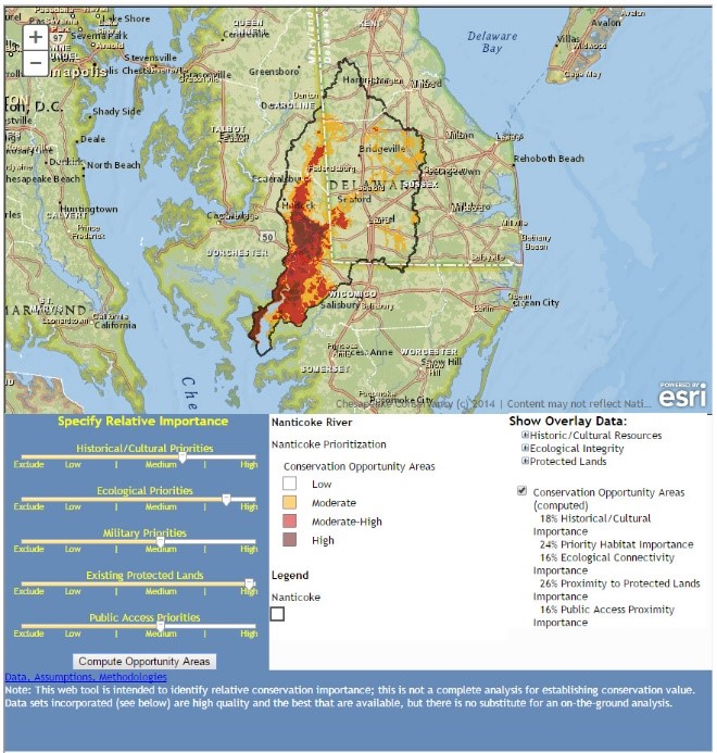
The Analyst enables users to identify high priority landscapes according to the user’s goals and also gain a better understanding of how regional priorities change based on the importance placed on any given category. Locating areas that are persistently significant as the relative weighting of each category is changed will help large landscape conservation planning efforts identify priorities that will satisfy the needs of a number of constituent groups and protect the region’s most valuable landscapes.
“The Nanticoke River Conservation Opportunities Analyst represents a way that the Conservancy and partners can build on current conservation successes along the Nanticoke and expand those efforts to high priority landscapes throughout the broader watershed. We hope this tool will be used to build consensus around future opportunities that will protect the region’s highest value cultural, historical, and ecological resources,” said Jeff Allenby, director of conservation innovation for the Chesapeake Conservancy.
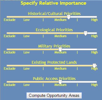 Hosted online through Chesapeake Conservancy’s website, the Nanticoke River Conservation Opportunities Analyst allows users to adjust five sliding bars to characterize how they value each type of resource. After a user adjusts each slider and clicks the “Compute Opportunity Areas” button, a weighted overlay analysis is completed on Chesapeake Conservancy’s servers and a composite layer showing landscapes with a High, Moderate-High, or Moderate potential is returned. Users can pan and zoom on the map to view specific areas of interest and understand how the landscape around them ranks. Because the analysis typically takes only 10-15 seconds, it is easy to run multiple scenarios, adjusting the weight of each category to see which high-value areas change and which remain the same.
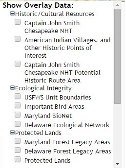 In addition to performing a custom analysis to identify regional priorities, visitors to the site can also view many of the background datasets on which the analysis is based by expanding the “Show Overlay Data” lists. These datasets are based on cultural, historical, and ecological resource information provided by the National Park Service, US Fish & Wildlife Service, North Atlantic Landscape Conservation Cooperative, Department of Defense, Maryland Department of Natural Resources, Delaware Department of Natural Resources and Environmental Control, and the National Register of Historic Places. Each of these layers can be turned on and off by selecting the check box next to the layer name to see how they relate to the high-value landscapes identified through the analysis.