Partners Create Online Tools for Landowners Considering Conservation Options
Annapolis, MD – Landowners considering conservation in Maryland’s Frederick and Washington counties; Virginia’s Augusta, Rockingham, Shenandoah, Frederick, Page, and Warren counties; and West Virginia’s Jefferson and Berkeley counties have access to new online tools to better understand and incentivize their options.
Provided by a partnership of conservation organizations – including the Safe Water Conservation Collaborative (SWCC), the Heart of Maryland Conservation Alliance (HMCA) and the Shenandoah Valley Conservation Collaborative (SVCC), enlisted the expertise of Chesapeake Conservancy’s Conservation Innovation Center (CIC) to build three new online tools. The partnership hopes that the tools will help landowners better understand the importance of the environmental and cultural features of their properties, perhaps incentivizing them to choose conservation and better protect their land. This work was funded by the Land Trust Alliance’s Chesapeake Bay Land and Water Initiative grant program.
“We’re grateful for the support from the Land and Water Initiative,” said David Lillard, executive director of Catoctin Land Trust, which hosts the Heart of Maryland Conservation Alliance. “This tool will help me, when I sit with a property owner on their porch, to share how their land fits into the mosaic of water, landscape, history and their neighborhood.”
“This tool will be a game-changer for the Safe Water Conservation Collaborative,” said Berkeley County Farmland Protection Board Executive Director Mark Schiavone. “The parcel identification tool will allow interested property owners to see if their property has significant conservation values and to drill into the data to see what attributes are significant. And, it will allow the public to see which properties in our region are important for land conservation efforts.”
“I hope that this tool will provide a direct and efficient way to connect landowners with the providers of technical assistance for conservation efforts on their properties. This tool can help landowners understand the features of their property that are relevant for the different conservation programs available to them and reduce the work of trying to figure out who they should be working with to enroll,” said Shenandoah Valley Conservation Collaborative Project Manager Kevin Tate.
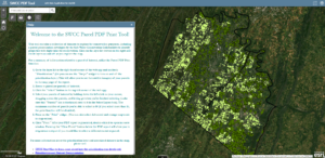
 The three customized online tools generate conservation reports on land parcels. The reports contain information important to conservation decisions, such as the total area, acreage of tree canopy, length of any streams and if there are any historic features on the parcel of cultural importance. The CIC used a variety of local, state, and regional datasets along with the latest high-resolution land cover data to populate these tools.
“This is a great example of using technology to benefit the conservation movement—in this case, at the landowner level—empowering, and we hope inspiring, landowners to make the most informed decisions as caretakers and stewards of their land,” said Chesapeake Conservancy Geospatial Analyst Mary Molloy.
To view the tools, visit: HMCA PDF Tool, SVCC PDF Tool, SWCC PDF Tool.