Chesapeake Conservancy Releases Virtual Tour of York River
Custom Pontoon Raft Fitted with Six-Camera Array Captured Images of Entire River System
 Annapolis, MD – Today, Chesapeake Conservancy released a virtual tour of Virginia’s York River and its tributaries, the Pamunkey and Mattaponi. As part of the John Smith Chesapeake Trail Riverview series, users can virtually travel down the rivers from the perspective of a paddler with their computer, smartphone, or tablet, and also have access to a number of conveniences including geographic locations, historical information, and recreational amenities.
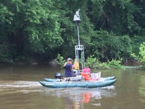
The Conservancy partnered with Richmond-based Terrain360.com to deploy their one-of-a-kind, custom-made boat equipped with six cameras mounted on the vessel 10 feet above the water’s surface which captures high-resolution 360-degree images. The cameras are controlled by a central computer, which also automatically captures GIS data, weather data, light data and directional data at 40-foot intervals. These images were then stitched together to create a digital image map of the York River, accessible by anyone with an Internet connection. The virtual tours are available to the public on the Chesapeake Conservancy’s web site at www.chesapeakeconservancy.org.
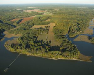
Not yet open to the public, Werowocomoco is now a part of the National Park System and the John Smith Chesapeake Trail.
“Our virtual tour of the York River features the latest addition to the National Park Service, Werowocomoco. While not yet open to the public, users of the virtual tour can get a sneak peek of Werowocomoco’s waterfront along the John Smith Chesapeake Trail,” Chesapeake Conservancy President and CEO Joel Dunn said.
“The York River and its tributaries are extremely important to our history. American Indians from the Mattaponi and Pamunkey and other tribes still live along the rivers today. Captain John Smith’s interactions with these tribes 400 years ago helped him accurately map the surrounding region during his explorations of the Chesapeake,” Dunn said. “At the Chesapeake Conservancy, we believe that connecting people to the natural wonders of the Chesapeake, as well as the history and culture of the people who have lived here for hundreds of years is vital to fostering the stewardship necessary to protect and conserve this national treasure.”
 “It took several months for us to map the York, Mattaponi, and Pamunkey rivers, where we captured 300,000 images and 100GB of Lidar data,” Terrain360 cofounder Ryan Abrahamsen said. “The Pamunkey is very secluded. In fact, we didn’t see another soul the entire upper Pamunkey, but we did see more than 100 bald eagles. A highlight of our trip on the York was seeing a group of dolphins just 10 miles from West Point.”
In addition to the York, the Conservancy’s other Riverview virtual tours include the Elk, North East, Sassafras, Nanticoke, Patapsco, Potomac, Rappahannock, York, the main stem and West Branch of the Susquehanna, and the James in partnership with the James River Association.
The York River runs 35 miles from West Point, Virginia and empties into the main stem of the Chesapeake Bay. The York forms at the confluence of the Pamunkey and Mattaponi Rivers.
###
The Chesapeake Conservancy’s mission is to strengthen the connection between people and the watershed; conserve the landscapes and special places that sustain the Chesapeake’s unique natural and cultural resources; and restore landscapes, rivers, and habitats in the Chesapeake Bay region. We empower the conservation community with access to the latest data and technology. As principal partner for the National Park Service on the John Smith Chesapeake Trail, we helped create 108 new public access sites and permanently protect some of the Bay’s special places like Werowocomoco, Blackwater National Wildlife Refuge, Harriet Tubman Underground Railroad National Historical Park, and Fort Monroe National Monument. www.chesapeakeconservancy.org