Chesapeake Conservancy Releases Virtual Tours of Elk, North East, and Sassafras Rivers
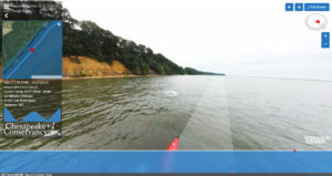 Annapolis, MD – Today, Chesapeake Conservancy released virtual tours of three rivers at the head of the Chesapeake Bay. Users can virtually travel down the Elk, North East, and Sassafras Rivers from the perspective of a paddler with their computer, smartphone, or tablet, and also have access to a number of conveniences including geographic locations, historical information, and recreational amenities. The Conservancy partnered with Richmond-based Terrain360.com to deploy their one-of-a-kind, custom-made boat equipped with six cameras mounted on the vessel 10 feet above the water’s surface which captures high-resolution 360-degree images. The cameras are controlled by a central computer, which also automatically captures GIS data, weather data, light data and directional data at 40-foot intervals. These images were then stitched together to create a digital image map of each river, accessible by anyone with an Internet connection. The virtual tours are available to the public on the Chesapeake Conservancy’s web site at www.chesapeakeconservancy.org. “The Chesapeake Conservancy believes that connecting people to the Chesapeake Bay and its great rivers is critical to protecting and restoring the health of the watershed. However, it is difficult to make people fall in love with something they have never seen. While nothing beats seeing the beauty of the Chesapeake firsthand, these virtual tours take users into some of the more remote places in the region,” Chesapeake Conservancy President and CEO Joel Dunn said. “For example, parts of the Sassafras River are too shallow for big power boats, but perfect for kayaking. Our hope is that these tours encourage people to go out and experience these amazing places and help them plan their trips.”
 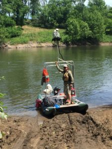 “Mapping these three rivers was a great experience which spanned from rough weather to still waters,” Terrain360 cofounder Ryan Abrahamsen said. “We had to make several trips to the Sassafras due to rain, creating 40,000 images of the very secluded and peaceful river. On the Elk, we faced a small craft advisory and enjoyed camping at Elk Neck State Park for several nights. The North East only took one day to map.” In addition to the Elk, North East and Sassafras, the Conservancy’s other Riverview virtual tours include the Nanticoke, Patapsco, Potomac, Rappahannock, York, the main stem and West Branch of the Susquehanna, and the James in partnership with the James River Association. The North East River stretches five miles from North East, Md. to the main body of the Chesapeake Bay and is entirely tidal. The Elk River is on the northern edge of the Delmarva Peninsula and runs for approximately 15 miles. Also on the Delmarva, the Sassafras River begins in New Castle County, Del. and runs for 22 miles between Cecil and Kent counties to the Chesapeake Bay.
###
The Chesapeake Conservancy’s mission is to strengthen the connection between people and the watershed; conserve the landscapes and special places that sustain the Chesapeake’s unique natural and cultural resources; and restore landscapes, rivers, and habitats in the Chesapeake Bay region. We empower the conservation community with access to the latest data and technology. As principal partner for the National Park Service on the John Smith Chesapeake Trail, we helped create 108 new public access sites and permanently protect some of the Bay’s special places like Werowocomoco, Blackwater National Wildlife Refuge, Harriet Tubman Underground Railroad National Historical Park, and Fort Monroe National Monument. www.chesapeakeconservancy.org