UMBC and Chesapeake Conservancy to Create Detailed Stream Maps of Chesapeake Bay Watershed
Baltimore, MD – Thousands of waterways, from major rivers like the Potomac and Susquehanna to tiny headwaters, flow through the Chesapeake Bay watershed. Many of them appear on official stream maps produced by the U.S. Geological Survey, but many others go unrecorded.
Because the official maps are incomplete, “if you base management and restoration goals on coarse stream maps, you’re going to miss a big part of the picture,” says Matthew Baker, professor of geography and environmental systems at the University of Maryland Baltimore County (UMBC).
 Baker’s partnership with the non-profit Chesapeake Conservancy has been awarded $1.2 million from the Chesapeake Bay Program (CBP) to create a more accurate, updated map for the watershed by applying new stream mapping techniques.
The Chesapeake Bay Program is supporting accurate stream mapping to improve management and implementation of the Chesapeake Bay Total Maximum Daily Load—daily Bay pollution limits set by the U.S. EPA in 2010.
Small streams are often overlooked for restoration activities because they do not show up on the official maps, despite delivering large amounts of nutrient and sediment pollution to the Bay. Updated stream maps will help partners throughout the Chesapeake Bay watershed prioritize restoration efforts and better understand how pollution enters the Bay’s tributaries.
Innovative approaches
This project follows a previous Chesapeake Bay Trust (CBT) award to Baker and his Chesapeake Conservancy colleagues to develop the methods necessary to carry out such a daunting task. With traditional methods, “You need skilled personnel doing very tedious, detail-oriented work over a long period of time,” says Baker. “We look forward to continuing to develop more automated, efficient and cost-effective ways.”
Now, Baker and his team get the chance to take on the challenge of using their new techniques to create the most detailed map of the region’s waterways to date, in a fraction of the time required by previous methods.
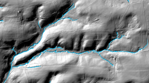
To identify previously unmapped stream channels, Baker and his team will analyze data from models of the terrain generated by light detection and ranging (LiDAR). This technology uses lasers emitted from aircraft to measure the relative height of Earth’s surface very precisely. But that’s just the beginning.
Baker’s team will remove inconsistencies and errors inherent to the LiDAR data, such as when the laser beam hits tree leaves or water surfaces instead of the ground. Then the team will find stream channels by creatively applying algorithms that interpret the terrain in the context of the surrounding landscape. The new maps may still not capture every single channel, but Baker hopes to get a lot closer while limiting false-positives.
Connecting the dots
“What the CBP was asking for was not just, ‘How do you find the channels?’, but, ‘How do you link them together in a connected network?’ And, ironically, that’s not a simple thing to do with this sort of detailed terrain information,” Baker says.
“For example, if a stream flows under a road, the road is interpreted as a kind of dam by conventional computer algorithms, even though our eyes and brain naturally connect the channel on either side,” Baker explains. Although such features are intuitive for people, computers need to be taught how to fill in those gaps accurately and appropriately.
Once the team develops a more complete map, they will still have one more crucial step to complete. “A big part of the project is to validate and check the map,” Baker says. “If the stream map isn’t reliable and no one believes it, then it’s not very useful. So that’s what we’re going to spend a lot of time doing.”
He estimates that about two-thirds of the time spent on the six-year project will focus on quality control. “With Chesapeake Conservancy’s assistance and expertise, we will compare the results of the new automated techniques with data collected from aerial imagery or on the ground at sites around the watershed.”
“Chesapeake Conservancy is a great partner in this context,” says Baker. “They’ve developed a lot of experience generating geographic datasets for the watershed.”
Conservation outcomes
Having a complete, reliable map is essential for protecting waterways. “If we want to understand how what we do on the landscape influences stream integrity and downstream health in places like the Chesapeake Bay,” Baker says, “then being able to map the connections between human activities on the land and the circulatory water system that delivers their effects to the Bay is paramount.”
Streams not visible on current official maps have already proven extremely important in research. Early evidence that vegetation alongside streams could reduce discharges of harmful pollutants into the Bay came from research on streams that weren’t on the best USGS maps at the time, Baker notes.
For now, the USGS has identified developing high-resolution stream maps as a national goal, and Baker hopes to contribute to that effort. The updated, verified map will enhance management and protection within the Chesapeake Bay watershed, and the methods Baker and the Chesapeake Conservancy have developed have the potential to improve stream mapping—and to better protect waterways—across the nation and the world.