Partners Highlight James River Water Quality Achievements
New StoryMap and Tracking System Shows 3 Years of Progress
Annapolis, MD – Today, the Virginia Environmental Endowment (VEE), Chesapeake Conservancy and The Commons released a new visual graphic computer platform called a “StoryMap” highlighting achievements in improving water quality of the James River in Virginia made possible by the Endowment’s grant program, the James River Water Quality Improvement Program (JRWQIP), which began in 2018. The nearly 350-mile-long James River is among the longest rivers in the Chesapeake Bay region flowing from the Appalachian Mountains to the Bay.
The JRWQIP is funded by a $15.595 million grant program designed to accelerate and advance water quality improvements for the James River. Funding for the program was made possible by the mitigation package negotiated by the Commonwealth of Virginia that resulted from the permitting of the Surry-Skiffes electrical power line river crossing near Jamestown.
 In 2018, to support VEE’s grant program, the Chesapeake Conservancy’s Conservation Innovation Center developed a “Restoration Planner,” a web-based application to support planning and evaluation of restoration projects and to support VEE’s desire to make the biggest impact possible with its grant funding.
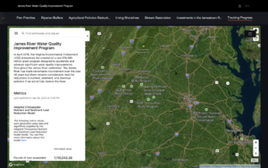
Produced by the Chesapeake Conservancy’s Conservation Innovation Center, the new StoryMap highlights some of the achievements made by the grantees since 2018, including new riparian buffers, agricultural pollution reduction practices, living shorelines, stream restoration projects and investments in the Jamestown region.
VEE’s JRWQIP grantees track details and impacts of their work using an online platform called FieldDoc, which was developed and is maintained by The Commons to manage and visualize progress.
“We are very pleased to showcase the improvements made thus far to the James River by our 13 grantees,” said VEE’s Executive Director Joseph Maroon. “Together, through efforts such as streamside buffer plantings, stream restoration projects, living shorelines, septic system upgrades and animal waste storage the grantees have reduced nitrogen pollution to the River by 319,558 pounds a year, phosphorus by 26,640 pounds per year and overall suspended sediment by over 7 million pounds. We hope this new StoryMap will help interested persons and organizations envision the totality of efforts while inspiring other partnerships and similar efforts in the James and throughout the region.”
John Dawes, executive director of The Commons added, “VEE’s use of FieldDoc to document the implementation of every conservation practice that counts towards JRWQIP goals is truly an innovative approach. Together VEE, The Commons, The Conservancy, and the restoration practitioners working tirelessly to improve water quality have set a new bar for transparency when it comes to sharing exactly where restoration is happening and the value it provides to the people living in the James River Watershed. We are thrilled to support this effort and be at the intersection of where software can help play an active role in getting these management practices on the ground and quantified.”
The Restoration Planner leverages the CIC’s high-resolution land cover and flow path data to identify and prioritize high-impact, cost-effective projects that maximize water quality benefits for the James River watershed.
“The Restoration Planner provides VEE and its grant applicants with information about where conservation and restoration projects are likely to produce the greatest water quality benefits,” said Chesapeake Conservancy’s Geospatial Technology Manager Emily Mills. “Its high-resolution data enables grantees to practice ‘precision conservation,’ implementing the right practices at the right scale to the right places and at the right time. Precision conservation means having a greater impact with investments of valuable resources–time and money.”
 The Restoration Planner provides a Google Maps-like interface where users can explore a wealth of data layers. They can zoom in to a specific restoration opportunity area (ROA) or parcel, and at the click of a button access information about that project such as its potential for reducing runoff and erosion. Users can also sort and filter opportunities based on criteria of interest within their geographies, helping to refine their search for high-quality projects in their communities.
This technologically advanced approach and resulting grant-funded projects complement Envision the James, an initiative Chesapeake Conservancy conducted along with partners such as the James River Association and National Geographic which specifically identified public demand for water quality restoration, recreational opportunities and wildlife habitat conservation.
The StoryMap can be viewed at http://bit.ly/JRWQIPStoryMap.